Wednesday, April 1, 2015

Drysdale By Pass Community Consultation starts mid April

The Geelong Advertiser reports today that"

"VicRoads is hosting open sessions where residents can see the latest options for the bypass, and provide input into issues such as intersections and improvements to High St....

Community consultation sessions will be held in:

— Drysdale on April 15 between 3pm and 7pm at the Springdale Neighbourhood Centre.

— Portarlington on April 22 between 3.30pm and 7pm at the Portarlington Neighbourhood

House."

Tuesday, March 17, 2015

Coles Supermarket in Drysdale gets the go ahead but what about the traffic?

The Geelong Council on 10 February 2015 passed the an Amendment C297 which rezoned the vacant land at 32 Murradoc Road, Drysdale, from the Commercial 2 Zone to the Commercial 1 Zone.

This Amendment was also combined with a planning permit to construct a full-line Coles supermarket at 24-26, 28-30 and 32 Murradoc Road, Drysdale.

The Council received 20 submissions, 16 in support or not objecting and 4 opposing the Amendment. The contentious issue was whether there was sufficient economic and policy justification for another supermarket in Drysdale at this time and consequential impacts to local traders and the Jetty Road developers.

Council referred the submissions to an Independent Planning Panel appointed by the Minister for Planning. The Panel Hearing was held in November 2014. The Panel concluded that the proposal was strongly supported by State and Local Planning Policy, was strategically justified and warranted, and would strengthen the role and function of the Drysdale Town Centre. The Panel was satisfied that the existing road network would adequately cope with the traffic generated by the new supermarket.

The minutes of the meeting are on the City of Greater Geelong Website.

From my perspective, the old house is gone and the site has been cleared - that is a good thing.  The trees apparently will be kept - also good.  However, it remains to be seen whether Murradoc Road can cope with an increase in the number of cars accessing the new supermarket. Its bad enough now on Wednesday and Saturday mornings when Aldi has their specials days.  The combination of the roundabout, and traffic lights and schools drop off and pick up times creates a huge traffic jam both in the morning and afternoon.

I have also noticed an increase in cars accessing Clarendon Road generating more corrugations and dust - many people are now using this as a way to bypass the town centre.  This will only get worse until the bypass is built and that wont be tomorrow.

So Coles - great for competition between Aldi and Woolworths but we no longer have a green grocer. It will be interesting to see how the existing retail outlets perform once Coles becomes operational.


Vicroads is currently working on the Drysdale Bypass Network Planning Study

"In November 2014, the Victorian Government committed $109 million to construct the Drysdale Bypass. This includes $106 million for the bypass and $3 million for an upgrade of High Street in Drysdale.

VicRoads is currently working on a Drysdale Road Network Planning Study and is developing a business case to fix traffic issues in Drysdale. The Study will focus on how the bypass can improve traffic flow through and around Drysdale, reduce congestion and the number of commercial vehicle trips through the town centre. It will also model future traffic patterns and through Drysdale, analyse crash statistics including those involving pedestrians and cyclists.

The design of the Drysdale Bypass will be squarely focused on safety, and will be constructed to provide the safest road environment which will reduce the risk of crashes and serious injuries…”


Three video clips from the breakfast briefing held at the Springdale Neighbourhood Centre are available for viewing below:


Friday, November 21, 2014

Where to vote in Drysdale / Clifton Springs for the State Election on Saturday 29 November

There will be three polling booths in the Drysdale Clifton Springs area on Saturday 29 November for the 2014 State election.
  • Drysdale Uniting Church Hall, Palmerston Street, Drysdale (Full wheelchair access)
  • Beacon Point Kindergarten, 49-55 Centaurus Avenue, Clifton Springs (No Wheelchair Access)
  • Clifton Springs Primary School, 84 Jetty Road, Clifton Springs (Full wheelchair access) 

Polling booths are open 8am - 6pm, 29 November.

Early voting centre for the Bellarine - Bellarine State EO - EVC, Shop 2 509 Bellarine Highway Moolap 3221 (Full wheelchair access)
  • 9am to 2pm Saturday 22 November
  • 8.30am to 8pm Thursday 27 November


Wednesday, November 19, 2014

Open Garden in Drysdale this weekend – Lark Edge

On behalf of Open Gardens Australia, Lark Edge will be open to the public this Saturday November 22 and Sunday November 23, from 10.00 am – 4.30 pm.

Lark Edge is located at 2065 Portarlington Road, Drysdale.

Developed over some 25 years, Lark Edge is a mature country garden on the north face of the Bellarine Peninsula, part of a smallholding which includes a domestic scale vineyard, orchard and grazing paddocks for alpacas.  

It started as a project to plant trees and hardy shrubs to clothe what had been a potato farm.  One half of the 4.5 ha property is fairly level, the other falls away toward Corio Bay with views to the You Yangs.   

Within a framework of woodland areas - pines, casuarinas, eucalypts, acacias and other species - are flower and vegetable gardens, a vineyard, Mediterranean terraces, alpaca fields, shrubberies, collections of pot plants and open spaces of lawns and grasses.  

The varied plantings are linked in a series of winding pathways through both shady and sunny areas. 

Open Saturday and Sunday - 10am - 4.30pm
Address2065 Portarlington Road, Drysdale.
Devonshire teas (St James Drysdale catering team)
Plant stall  (Friends of the Geelong Botanic Gardens)
Entry fee $8  - All proceeds to charity

Off-road car-parking is available, no coaches.  
Enquiries: (03) 5253 3340

More details are on the Open Gardens Australia website: http://www.opengarden.org.au/regions/vic_calendar.html

Monday, November 17, 2014

Drysdale Leopold Horse Show and Showjumping - Sunday 14 Dec 2014

Drysdale Leopold Pony Club is holding its annual horse and pony show on Sunday 14 December.

There will be events for:
  • Junior and Senior Pony Club
  • Open Rings
  • Topsy ring-Lunchtime Fancy Dress
  • Freshmans and 
  • Open AM7 Showjumping


Pre-entry is available, or you can enter on the day.

*Insurance: All open competitors must report to Secretary’s Office to present/sign day attendance form before riding.

Admission: $5.00 per car, PLUS $4.00 FOLLR fee per horse.

$3.50 per event rings 1-3 and there will be no refunds.

Gates will open at 7:00am

Rings will commence from 9:00am, with Freshmans show jumping starting at 8:30am.

Canteen will be available

You can return your ribbons in exchange for raffle tickets on the day.

Ribbons will be awarded to 4th place, with Champion and Reserve sashes also.

** RUGS AND GARLANDS will be awarded for PONY CLUB HIGH POINTS **

** RUGS DONATED BY HORSELAND GEELONG!! **

*Supreme Led *Supreme Ridden *Supreme Rider *Supreme Ridden Show Hunter
*Junior & Senior Pony Club High Point Awards* Topsy Trouper Trophy*

*Ribbons for Freshman’s SJ clear rounds*

**Prize money for AM7 Showjumping**

Location: Lake Lorne Reserve, Reserve Road, Drysdale
Melways ref. 470 G1
Enquiries: Sam Krause: 0410 870075

Wednesday, November 12, 2014

Winged Horse Equine Welfare Open Day and Horse Gear Market this Saturday

This Saturday 15 November, Winged Horse Equine Welfare is hosting an open day and horse gear market.  There will be new and used items, food stalls and a jumping castle for the kids (big and small).


There will be 100+ rugs for sale from 3'6 to 6'9 including cottons, synthetic rugs, canvas rugs plus neck rugs and many 6'6 good quality axiom synthetic and a few stable rugs and mesh rugs.

The day will run from 9.30 - 3pm and a gold coin donation is required for entry which will go towards running this charity.

The address is 215 Queenscliff Road, Portarlington. (Enter the property from Church Street).

You can visit the Winged Horse Equine Welfare on Facebook or on the web at: http://www.thewingedhorse.org/


Monday, November 10, 2014

Geelong Council proposes new boundary between Drysdale and Clifton Springs

There is a new retirement village being constructed, known as Bellarine Springs.  The current boundary alignment for Drysdale / Clifton Springs will run through the centre of this retirement village which will split the development into two separate localities.

Geelong Council is proposing to realign the boundary further north to run along the back fence line of properties located on Amarina Road, Clifton Springs.

The Council is consulting on this proposal from 7 November until 13 December 2014.

Below is a map showing the proposed changes:

More information is available from: the City of Greater Geelong.

Friday, October 17, 2014

Drysdale ByPass could be built if the Victorian Coalition Government gets back in

The Geelong Advertiser reports today that

"THE long-awaited Drysdale bypass will be built if the Coalition is returned to government next month.

Premier Denis Napthine will today make an official $106 million election commitment to build the road in the hotly contested seat of Bellarine.


Plans seen by the Geelong Advertiser show the two-lane road will stretch for 5.9km from the major roundabout on the southwest entry to the town and rejoin Portarlington Rd to the town’s north near Whitcombes Rd..."


The road will be started in 2016 and completed in 2019.


Tuesday, May 6, 2014

Drysdale Bypass Business Case Funded in today's State Budget

The Victorian Treasurer's budget speech today has announced:

"$3.6 million has also been allocated in 2014-15 for planning, project development and the
preparation of business cases for the Drysdale bypass, Westall Road extension, Edgars
Road extension in Epping and a northern extension of the Mornington Peninsula Freeway
to bypass Mordialloc..." page 7. http://www.dtf.vic.gov.au/State-Budget/2014-15-State-Budget/Treasurers-Speech

Monday, April 21, 2014

Geelong Council to consider Permit for a Coles Supermarket in Drysdale next to Aldi

Geelong Council will consider a permit from Coles to build a new supermarket in Murradoc Road Drysdale next door to Aldi this Tuesday night (22 April 2014).

Road congestion will reign supreme even more so than it does now - can't see the need for another supermarket - the dollar on spreads so far.

Below is the summary from the Council's agenda document which is in pdf format. The agenda item had detailed information - just follow this link.

Amendment C297 And Permit 765/2013 – Proposed Coles   Supermarket On Murradoc Road, Drysdale

Portfolio: Planning - Cr Heagney
Source Planning and Tourism - Strategic Implementation
General Manager: Peter Bettess
Index Reference Council Reports 2014

Purpose

This report seeks Council approval to exhibit a combined planning scheme amendment and permit to facilitate the development of a supermarket on Murradoc Road, Drysdale.

Summary

  • A planning scheme amendment request and planning permit application was made by ERM Australia on behalf of Coles Group Property for land at 24-32 Murradoc Road, Drysdale.
  • The amendment proposes to rezone 32 Murradoc Road from the Commercial 2 Zone to the Commercial 1 Zone. The remainder of the subject land is presently in the Commercial 1 Zone.
  • The permit application (765/2013) is for buildings and works to construct a supermarket, the display of identification signage, a reduction of car parking requirements, the alteration of access to a road in a Road Zone Category 1 and to create a carriageway easement.
  • The proposed supermarket has a total floor area of 3,892 sq metres, is of contemporary design and provides good connectivity with the adjacent ALDI store. Vehicle access is from Murradoc Road and a dedicated pedestrian path will connect the newly developing residential estate to the south, through the site, to Murradoc Road.
  • The proposal is supported by Council's adopted Drysdale Urban Design Framework August 2012, which identifies the site for a supermarket.
  • Relevant to the consideration of this application is the likely opening date of the supermarket and how this would impact on the nearby Jetty Road Neighbourhood Activity Centre, where a 3,200 sq metre Woolworths supermarket is to be constructed and operational by April 2015.
  • The economic assessment submitted as part of the Amendment request concluded that the economic and social benefits from the Coles supermarket significantly outweigh any impacts on commercial competitors. The assessment however failed to factor-in the new Jetty Road Centre (instead expecting it to be developed over the medium to long term).
  • Council officers commissioned consultant Tim Nott to provide an independent review of the likely economic impact of the proposal.
  • The review clearly demonstrates that if the two supermarkets are developed as planned, the food and grocery segment throughout the trade area is likely to experience a very low level of turnover. Mr Nott finds that there is likely to be room for two supermarkets by the mid-2020s, in line with expected population growth.
  • Mr Nott estimates that the Jetty Road NAC would suffer a significant loss of around 16% in total retail sales compared with what is currently anticipated. It would appear that both Coles and Woolworths are well aware of the likely economic challenges over the coming 10 year period, but still committed to establishing new supermarkets in the locality as soon as possible.
  • The net community benefit of the proposed Coles, particularly in strengthening the role of the Drysdale Town Centre and improving the level of competition in the local food and grocery sector, is considered to outweigh the short to medium term negative impact on the Jetty Road NAC and potential reorganisation of retail space in the trade area.
  • It is recommended that the Amendment be placed on public exhibition to allow interested parties, including other business owners and operators in the trade area, an opportunity to make submissions.

Recommendation

That Council resolves to:
1) support the preparation and exhibition of Amendment C297 to the Greater Geelong Planning Scheme to rezone the land at 32 Murradoc Road, Drysdale, from the Commercial 2 Zone to the Commercial 1 Zone;
2) consider the application for a planning permit for a Coles supermarket on the land at 24-26, 28-30 and 32 Murradoc Road, Drysdale, concurrently with the preparation of the Amendment in accordance with the Planning and Environment Act, and that draft Planning Permit 765/2013 be prepared and exhibited with the Amendment, subject to resolution of the detail of the permit conditions; and
3) request the Minister for Planning to authorise the preparation and exhibition of Amendment C297 and Planning Permit 765/2013.

Thursday, April 17, 2014

McHarrys Bus Depot Permit Application before Geelong Council on Tuesday 22 April

At the Geelong Council meeting on Tuesday 22 April 2014 the Council will consider the planning permit for McHarrys Buslines in Murradoc Road and an amendment for the Drysdale Urban Design Framework to enable the planning permit to be considered. As there are objections to the permit, Council will be referring this to an independent panel to resolve.

Council believes adopting the Drysdale Urban Design Framework provides a strong policy basis for the rezoning of the land along Murradoc Road, up to the Drysdale Bypass route, to Commercial 2 zone. This affects both sides of Murradoc Road including on the south side two small rural holdings either side of Clarendon Road.

Below is the summary from the Council's agenda document which is in pdf format still and over 13mb in size.

Combined Amendment C283 Drysdale Urban Design Framework/Permit 1060/2013 McHarrys Buslines – Consideration of Submissions

Portfolio: Planning - Cr Heagney
Source Strategic Implementation
General Manager: Peter Bettess
Index Reference Subject – Council Reports 2014 - Application C283

Purpose

The purpose of this report is to enable Council to consider submissions to combined Planning Scheme Amendment C283 Drysdale Urban Design Framework and Planning Permit Application1060/2013 for McHarrys Buslines, 97-105 Murradoc Rd, Drysdale.

Summary

  • Combined Amendment C283 and Permit 1060/2013 proposes to introduce a number of Ordinance and Zone changes to the Planning Scheme to reflect the recommendations of the adopted Drysdale Urban Design Framework (UDF) and enable McHarrys to establish a bus depot at 97-105 Murradoc Rd, Drysdale.
  • The Drysdale UDF applies to the Drysdale town centre and immediately surrounding land. The Amendment updates the Municipal Strategic Statement, introduces Commercial 1 & 2 zones in Murradoc Road and Collins Street and applies new Design and Development Overlays over the town centre commercial areas to reflect the recommendations of the UDF.
  • Permit 1060/2013 which accompanies the amendment would enable McHarrys to establish a new bus depot on a 1.2 hectare property (to be rezoned Commercial 2) at 97-105 Murradoc Road, Drysdale. This property is occupied by a detached house and some scattered vegetation.
  • Amendment C283 was placed on public exhibition from 23 January 2014 until 24 February 2014. A total of nine submissions have been received of which six either support or offer no objection and three of which object to parts of the amendment and/or draft permit.
  • Two submissions (one objecting) have been made about the provisions of the new Design and Development Overlays, in particular DDO33 as it applies to land at 26-32 Murradoc Road on which a new Coles supermarket is being proposed. These Overlays have received wide community acceptance and this report argues there is no justification for changes to be made to the exhibited provisions.
  • There is one supporting submission and two objecting submissions to the McHarrys bus depot which essentially request that no permit issue. However given that the proposed Commercial 2 zoning of this part of Murradoc Road is consistent with the recommendations of the UDF, refusal of the permit would be difficult to justify. One of these submitters also objects to the proposed Commercial 2 zoning in Murradoc Road.
  • In such circumstances where submissions are unable to be resolved, Council must refer them to an Independent Panel to be appointed by the Minister for Planning.

Recommendation

That Council having considered all submissions to Amendment C283 to the

Greater Geelong Planning Scheme resolves to:

1) Request the Minister for Planning appoint an Independent Panel under part 8 of the Planning and Environment Act 1987.

2) Refer all submissions to the Panel; and

3) Submit to the Panel its response to the submissions generally as outlined in this report.

Showjumping comes to Drysdale Easter Sunday and Monday

Drysdale Leopold Pony Club is hosting its annual showjumping carnival this Easter Sunday and Monday at Lake Lorne Reserve in Drysdale.

Sunday is an open competition and Freshmans show jumping is available - You can enter on the day - $5 per round - PLUS $4 FOLLR Facility Fee per combination per day (covers both Freshmans and Open). This ring will start at 10.00am at 35cm (may be led) and will progress in 10cm intervals
All clear rounds in Freshmans will receive an Easter Egg.

There is an open AM7 competition starting at 50cm, and going up to 60cm, 70cm, 80cm and 90cm classes - If time/entries permit, the heights may go up.

Ribbons will be awarded to 4th place. Prize money – 1st $15, 2nd $10, 3rd $5. There must be at least four entries in the class before prize money will be awarded.

A Judge’s Award will be made for the – 60cm class only – awarded by the judge to the combination that doesn’t necessarily win but shows excellent skill, sportsmanship and presentation. Rug is proudly sponsored by AVERY EARTHMOVING.

On Monday is Round 3 of the PCAV Barwon Zone BEST competition.

Full canteen is available on both days.

So come and ride or come and cheer our local riders on.


Sunday, February 9, 2014

Drysdale gets a new service station - where is the consultation?

City of Greater Geelong is considering a a permit to have a new Milemaker service station located at the Jetty/Grubb Road roundabout in Drysdale.

The first I heard about it was reading it in the Bellarine Times 6th February edition on Saturday. The closing date for submissions was the 7th February - the day before. Trying to find information about this on the Geelong Council website proved fruitless. Or maybe I was looking in the wrong place?

Below I have included a list of articles I found online about the proposal - including a map from the Drysdale Clifton Springs Community Association which I have linked to below.

I have posted on the Geelong Mayor - Darryn Lyon's Facebook page tonight asking him to investigate the proposal. He has undertaken to get back to me tomorrow.

Servo bid reveals lights 'plan'

By JOHN VAN KLAVEREN, The Bellarine Independent, 6 February 2014

AN APPLICATION for a third Drysdale service station indicates Vicroads proposes to replace the town's congested Jetty-Grubb-Portarlington roads roundabout with traffic lights. But Vicroads said it was only investigating and had no plans to upgrade the intersection. A Caltex service station with six double car fuel pumps and

Association puts servo permit under the pump

The Bellarine Times, James Taylor February 6, 2014

The City of Greater Geelong (COGG) is seeking feedback on a plan to build another service station in Drysdale, but the Drysdale and Clifton Springs Community Association has challenged the council's handling of the application process and the proposal's explanation of how it complies with planning laws.

Milemaker Petroleum has applied for a permit to build a service station at 331 Jetty Road, Drysdale, on the wedge of land between Jetty Road to the west and Geelong-Portarlington Road to the east.

The site – which is just over 2,996 square metres in size – will include a car refuelling area with six double-sided pumps, a truck refuelling area with two pumps, a 400-square-metre service station building and seven car parks.

Community Group Says a Firm "no"

by Stephanie Drysdale & Clifton Springs Voice, February 2014.

"The Drysdale and Clifton Springs Community Association is objecting to a proposed industrial scale project. A six double-pump service station has been proposed on the land running between the southern ends of Jetty Road and Portarlington Rd in Drysdale.

The application made to the City of Greater Geelong by Caltex franchisee Milkemaker Petroleum has the community group up in arms, believing the application has been made inept for public comment as well as transgressing and contradicting many planning policies..."

Council restricts public comment on proposed new service station in Drysdale

Drysdale Clifton Springs Community Association, Wednesday, January 29, 2014.

Caltex franchisee Milemaker Petroleum has applied to the City of Greater Geelong (CoGG) to build a service station with 6 double-pumps on the land between the southern ends of Jetty Road and Portarlington Road.

Proposed location of the new service station in Drysdale

CoGG has invited public comments on the proposal during the period 21 January to 7 February 2014. A plan of the proposal is shown above. The red triangle shows the property affected; the blue arrow on the right points to the location of the proposed service station; and the proposal includes plans for a road connecting Jetty Road and Portarlington Road across the property, but this isn't shown.Details of the proposal are allegedly available from CoGG's web site, but today, at least, they weren't! ..."

Wednesday, January 22, 2014

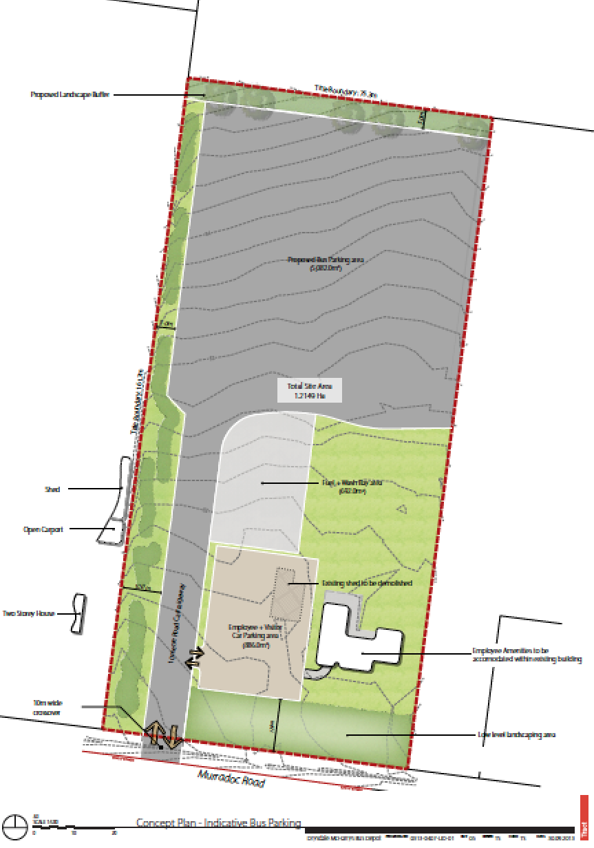
McHarry’s Buslines wants to build a depot in Murradoc Road Drysdale

McHarry's Buses wants to build a depot for its buses in Drysdale and turn a beautiful park like setting into a bitumen heat sink.

To make this happen,  the Geelong Council is running a Public Exhibition of the Drysdale Urban Design Framework Amendment C283.

The amendment is open for comment from anyone who wants to from 17 January 2014 to 24 February 2014.

The land affected by the amendment applies to all land in and around the Drysdale town centre within the Drysdale Urban Design Framework study area.

The land affected by this particular application is 97 – 105 Murradoc Road, Drysdale and McHarrys Buslines has applied for the permit.

The Amendment proposes to make changes to the Municipal Strategic Statement and apply new zones and overlays in accordance with recommendations of the Drysdale Urban Design Framework. 

The application is for a permit for buildings and works and new road access in association with a bus depot.

Currently this block has a house on an open park like environment with lots of trees.

It is proposed to keep the existing house, but around 75% of the grounds will be either put under bitumen or paving. The amount of fumes, maintenance noise, heat reflection which will be generated will affect the residents either side of this eyesore, not to mention the number of large vehicles going to this depot and in and out of the entrance will increase heavy vehicle traffic on Murradoc Road.

This will compound the existing traffic making its way to the council tip. Something all of us in Murradoc Road are really looking forward to.

Below is a plan showing what McHarry's proposes to do with this site.


More information about the proposed amendment is available from the City of Greater Geelong website. And they call this progress.

Friday, October 25, 2013

Come to the Drysdale Leopold Pony Club Show on December 8

The Drysdale Leopold Pony Club is holding its open horse show on Sunday December 8, 2013

There will be events for Junior and Senior Pony Club riders, Open Rings, Topsy ring, Lunchtime Fancy Dress, Freshman’s Showjumping and the Obstacle course starts at 10:00am.

Pre-entry is available, or you can enter on the day or you can just come and watch.

Admission: $5.00 per car, plus $4.00 FOLLR fee per horse
$2.00 per pedestrian/rider without vehicle
$3.50 per event, no refunds
Gates open 7:00am ; Rings commence 9:00am
There will be a full Canteen available

Ribbons will be awarded to 4th place, with Champion and Reserve sashes.

Class will include:

  • Supreme Led 
  • Supreme Ridden 
  • Supreme Rider 
  • Supreme Ridden Show Hunter 
  • Junior & Senior Pony Club High Point Awards
  •  Topsy Trouper Award
  • Ribbons for Freshman’s showjumping clear rounds


Where do you go:
DRYSDALE LEOPOLD PONY CLUB
Lake Lorne Reserve
Reserve Road, Drysdale
Melways ref. 470 G1

The full program is available from http://www.drysdaleleopold.ponyclubvic.org.au/

Enquiries: Sam Krause: 0410 870075, Kylie Berry: 0403 622115

Wednesday, July 31, 2013

Drysdale's Murradoc Road's shoulders abandoned by VicRoads?

It appears VicRoads have stopped work on sealing Murradoc Road's shoulders.

While they did a great job of rolling part of the shoulders and fixing the gravel as well as fixing some of the drains, they have not finished the work.

The Drysdale side of the big hill is a bit of a mess - the shoulders encroach over the road - part of the bitumen has disappeared.

On the St Leonards side of the hill the shoulders have just been left.

Did VicRoads not allocate enough money to finish the job?

Such a pity - it would have been great for the cyclists for summer.

Hope they come back and do what we all thought they were going to do, otherwise it is all a bit of a let down :-(

Wednesday, May 1, 2013

Murradoc Road's shoulders are getting sealed - finally a safer road for cyclists!

A letter arrived in the mail today from VicRoads:
Construction Works - Murradoc Road between Mortimer Street and Becks Road, Drysdale
VicRoads wishes to advise you that construction works on Murradoc Road between Mortimer Street and Becks Road, Drysdale will commence on Monday 6 May 2013.
Works will include construction of a sealed shoulder and road safety improvements in both directions of Murradoc Road.
Works will be carried out within the hours of 7am and 5pm Monday to Sunday, subject to weather and are expected to be completed by end June 2013.
Finally the shoulders will be sealed and it will be safer for cyclists.  This is a great win for everyone!

Tuesday, March 12, 2013

Geelong Council to cut Coriyule Road in two and rename the eastern end Appleby Street

At tonight's meeting of the City of Greater Geelong Council, councillors will vote on truncating Coriyule Road at its eastern end and in the process, creating a new road called Appleby Street. In effect Coriyule Road will cease to be a through road between Hermsley Road and Jetty Road.

If you live on the western side of the truncation you will either have to go all the way up to Hermsley Road and then down the Port road to get to Drysdale - or looking at the map you could weave your way around all the back streets (once they are all made) in the new estate and come out on Jetty Road - probably opposite Windham Street.

Council proposes that there will be a north south road to take the western traffic onto the Port Road - however, I can't see that happening in the near future - that could be years away. Not only that trying to dodge the traffic when turning right from Hermsley road onto the Port Road towards Geelong during peak times without getting run over the top of is a challenge in itself.

One also questions the ability for people to quickly exit the area east if the farming land is on fire and moving east with a westerly behind it - Coriyule road will be truncated - no north south road - where does one go?

Nothing like making it difficult for people to get where they need to go easily - why go in a straight line when you can enjoy creating traffic for others in normally quiet suburban streets.

Below is the extract from tonight's agenda enabling this truncation and road renaming to occur.

ROAD RENAMING - EASTERN SECTION CORIYULE ROAD TO APPLEBY STREET, CURLEWIS

Portfolio: Governance – Cr Fagg - Mayor
Source: Corporate Services - Financial Services
General Manager: Jeff Wall
Index Reference: Subject/Financial Management-Reporting
Subject/Roads, Footpaths & Streets

Summary

  • The current subdivisional development to the west of Jetty Road, Drysdale will result in Coriyule Road splitting into two separate roadways. It is proposed to rename the eastern ection of Coriyule Road to "Appleby Street" Curlewis.
  • The applicable section of Coriyule Road exists in the locality known as Drysdale, however this area of the locality is in the process of being renamed to Curlewis, as resolved by Council on 13 November 2012.
  • The proposed renaming of the eastern section of this roadway will enable all future properties to have unique identifiable street addresses.
  • The proposed name has been chosen from Council's ANZAC register.
  • This proposed renaming was advertised in The Independent newspaper on 3 August 2012 and the Geelong Advertiser newspaper on 4 August 2012.
  • Two submissions were received. One submission was against the proposal suggesting other names that do not comply with requirements. The other submission was in favour.

Recommendation

That Council approves the renaming of the eastern section of Coriyule Road, Curlewis to "Appleby Street", Curlewis.

Report

Background

New subdivisional development is occurring west of Jetty Road, Drysdale. This new development splits Coriyule Road, Curlewis into two separate roads (refer Attachment 1). It is proposed to rename the eastern section of Coriyule Road between Jetty Road and the truncation.

The applicable section of Coriyule Road exists in the locality known as Drysdale, however this part of the Drysdale locality is currently being renamed to Curlewis, as resolved by Council at its meeting of 13 November 2012. The majority of properties being accessed from this section of roadway are currently vacant land and therefore the renaming will not create a major impact / inconvenience to property owners.

The Heritage Victoria registered Coriyule Homestead is located on the section of roadway that retains the name "Coriyule Road". The name "Appleby Street" has been selected from the recently compiled ANZAC register of suitable road names. Mr Appleby served in the 2nd Pioneer Battalion and was born in Drysdale.

Discussion

As part of the functional road hierarchy planning for this subdivision, Coriyule Road has been truncated to lessen the importance and subsequent traffic volume of this road. Residents to the east of the truncation will be encouraged to use Jetty Road to access the main arterial road, namely the Geelong - Portarlington Road. Residents to the west of the truncation will have access to a proposed new north-south road that will provide access to the Geelong - Portarlington Road.

Renaming the section between Jetty Road and the truncation on Coriyule Road will eliminate any impression that there is a direct road link between Jetty Road and the future north-south road and Hermsley Road.

Renaming the eastern section of Coriyule Road will ensure compliance with the Guidelines for Geographic Names 2010. The Guidelines require a disjointed road to have separate names for each section of the roadway.

The suggested naming meets the requirements of the Geographic Place Names Act 1998 and the Guidelines for Geographic Names 2010.

The proposed renaming was advertised in The Independent newspaper on 3 August 2012 and the Geelong Advertiser newspaper on 4 August 2012 and all abutting land owners were notified at this time. Council received two submissions regarding this renaming.

One submission was against the proposed name and suggested two other names that are not suitable since they would cause a name duplication and do not comply with the Guidelines for Geographic Names 2010.

Environmental Implications

There are no environmental issues arising from this report.

Financial Implications

Council is responsible for street signage.

Policy/Legal/Statutory Implications

The Local Government Act 1989, Geographic Place Names Act 1998 and The Guidelines for Geographic Names 2010 have been followed and met. The proposal was advertised in The Independent newspaper on 3 August 2012 and the Geelong Advertiser Newspaper on 4 August 2012 with two submissions being received.

Officer Direct or Indirect Interest

There is no Council Officer direct or indirect interest involved in this report.

Risk Assessment

Should an emergency situation occur within this roadway, Council's proposal to rename this section will minimise the risk of emergency services not being able to locate the situation.

Social Considerations

The renaming of this section of roadway will allow for easy identification to the public and utility services in case of an emergency.

Communication

The proposed renaming of this roadway was advertised in The Independent newspaper on 3 August 2012 and the Geelong Advertiser newspaper on 4 August 2012.

Subject to Council and The Registrar of Geographic Names approval, the relevant authorities and abutting owners will be notified of the official registration of this road renaming.

Confirmation of the intention to rename was advertised in the Geelong Advertiser on 5 January 2013.

This map is the proposed development plan for Jetty Road and highlights the sections north and south of Coriyule Road for the proposed truncation. It is proposed to rename the section of road on the eastern side of the truncation to Appleby Street.

Geelong Council to change Drysdale Clifton Springs boundary tonight

Below is an extract from the City of Greater Geelong's Agenda which will be voted on tonight (12 March 2013) to change the boundary between Drysdale and Clifton Springs known as Area 1.

PROPOSED BOUNDARY REALIGNMENT – DRYSDALE / CLIFTON SPRINGS (WEST OF THE GEELONG – PORTARLINGTON ROAD)

Portfolio: Governance – Cr Fagg, Mayor
Source: Corporate Services – Financial Services
General Manager: Jeff Wall
Index Reference: Subject/Roads, Footpaths & Streets

Summary

  • Council resolved at its' meeting held on 8 May to commence a process of investigation and consultation to realign the locality boundaries between Drysdale and Clifton Springs.
  • After a process of community consultation, Council considered a further report on 13 November 2012 regarding an amended proposal to Area 1 of the Drysdale and Clifton Springs boundary realignment.
  • The amended proposal for Area 1 was advertised in the City News section of the Geelong Independent on 23 November 2012 and the Geelong Advertiser on 24 November 2012.
  • Two submissions were received in favour of the proposal and no submissions were against the proposal.
  • Once Council adopts the recommended amended boundary realignment, registration will occur in accordance with Geographic Naming requirements.

Recommendation

That Council approves the amended boundary realignment for Area 1 as follows:

To extend the existing Clifton Springs boundary from the rear of the property known as 52 Delungra Avenue in an easterly direction to the south east corner of the property known as 54A Delungra Avenue, then continue the Clifton Springs boundary north to intersect with the existing boundary at the rear of the properties known as 7 Wintersun Court and 12 Waterford Place (refer Appendix A).

Report

Background

Council is responsible for allocating geographic locality boundaries. Council received advice dated 16 February 2012 from the Registrar of Geographic Names requesting that in the interests of public safety Council proceed with a boundary realignment between Drysdale and Clifton Springs, west of the Geelong-Portarlington Road. Principal 3(A) of the Guidelines for Geographic Names 2010 stipulates that locality boundary should align with the cadastral fabric, road centre lines or easily distinguishable topographical features. In accordance with Section 3.2.1 of the guidelines, the Registrar may request Council to amend a locality boundary in the interests of public safety.

The locality boundary between Clifton Springs and Drysdale, west of the Geelong-Portarlington Road, passes through numerous residential properties in Wintersun Court and Narawi Avenue which is creating particular confusion for emergency and communication services. Ambulance Victoria has emphasised the need for correct locality to avoid confusion in an emergency response situation. In this case, the locality boundary does not comply with Principal the Guidelines.

Discussion

Council resolved on 8 May 2012 to commence a process of investigation and consultation to realign the locality boundaries between Drysdale and Clifton Springs. Following the community consultation process, including public meetings held on 8 and 15 August 2012, it was determined as part of the communities request to amend the Area 1 proposal.

A further report was tabled at the Council meeting of 13 November 2012, with a revised proposal for Area 1 agreed.

This proposal was advertised in the City News section of the Geelong Independent on 23 November 2012 and the Geelong Advertiser on 24 November 2012. Letters were sent to all affected property owners / residents at this time advising them of the amended proposal. No submissions were received against the proposal and two submissions were received in favour of the amended proposal thanking Council for listening to resident concerns.

The above proposal meets the requirements of the Guidelines for Geographic Names 2010.

Environmental Implications

There are no environmental issues arising from this report.

Financial Implications

Council offers a standard assistance package to residents when their property address is altered. This assistance package consists of 10 postage paid envelopes and 10 Change of Address forms. Other assistance may be offered on a case by case basis.

Policy/Legal/Statutory Implications

The Geographic Place Names Act 1998, the Guidelines for Geographic Names 2010 and Council Policy have been followed and met.

Officer Direct or Indirect Interest

There is no officer direct or indirect interest in this report.

Risk Assessment

Council's proposal to realign this boundary will minimise the risk of emergency services not being able to locate properties.

Social Considerations

The realignment of this boundary will allow for easier identification to the public and utility services in case of an emergency.

Communication

The proposed realignment was advertised in the Geelong Independent newspaper on 23 November 2012 and the Geelong Advertiser newspaper on 24 November 2012.

Letters were also sent to the affected owners in Area 1 advising of the proposed realignment.

Subject to Council and the Registrar of Geographic Names approval, the relevant authorities and affected owners will be notified of the official Registration of the new alignment.

Appendix A

Appendix A - map showing current boundary and proposed boundary alignment between Drysdale and Clifton Springs known as Area 1